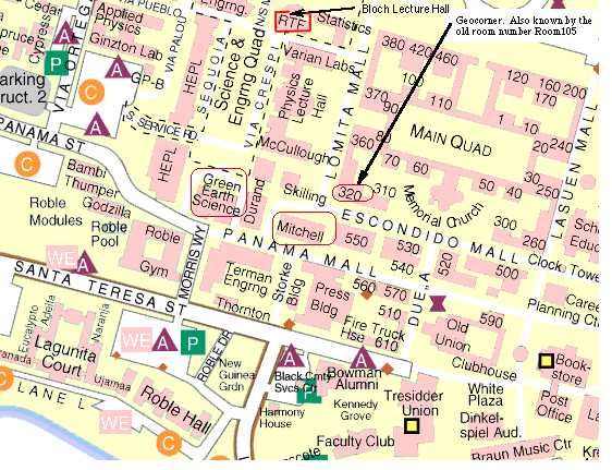
Location: Stanford University
see map
Anyone wishing to attend the lecture only is welcome at no cost.
This will be the 335th meeting since 1954.
Mount Shasta is a compound stratovolcano built by four overlapping volcanic cones on the stump of an even older stratocone that was largely destroyed about 300,000 years ago by a catastrophic avalanche 20 times larger than the 1980 avalanche of Mount St. Helens. Surmounting the wrecked volcano is a large stratocone between about 100,000 and 200,000 years old, the Sargents Ridge cone. Much of present Mount Shasta is formed by the Misery Hill cone, erupted between about 30,000 and 50,000 years ago, from a vent just north of Sargents Ridge.
Two Holocene cones overlie the glacially eroded older cones. Shastina, distinctly west of the bulk of Mount Shasta, is younger than 10,000-year-old pumice deposits of the Red Banks eruption. At the end of Shastina's cone growth, a series of viscous volcanic domes extruded in its summit crater, each plugging the feeding conduit until it was explosively shattered. Each explosion broke down the western crater rim to spread hot ash flows onto the flank of the volcano, followed by growth of another dome in the reopened crater. The last event related to the Shastina system was extrusion of the Black Butte volcanic dome low on its western flank. Black Butte rises steeply beside Interstate Highway 5 and partly collapsed into avalanches of hot debris. Parts of the towns of Weed and Mount Shasta are built on 9,400-year-old ash flows from Shastina and Black Butte. The other Holocene cone, the Hotlum cone, forms the present summit of Mount Shasta. Its activity began during the Shastina eruptions, but much it cone has grown since the disappearance of glaciers even larger than those that now partly cover it-glaciers that probably existed until about 6,000 years ago.
Mount Shasta last erupted about 200 years ago and for the past few thousands years typically has erupted every few hundred years. Future eruptions could produce lava flows, pyroclastic fallout, hot ash flows, and voluminous debris flows.
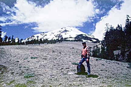
Bob Christiansen at Mount Shasta
Christiansen first joined the Geological Survey as a field assistant during the summers of 1954 and 1957and has been with the USGS continuously since 1961. He has studied volcanoes and volcanic geology around the world, especially in Nevada, Yellowstone National Park, Hawaii, and the Cascade Range of northern California. He is especially interested in the relations between volcanism and regional tectonics.
A summary of Christiansen's studies of volcanic evolution and volcanic hazards at Mount Shasta can be viewed at:http://volcanoes.usgs.gov/Hazards/Where/ShastaDanger/ShastaDanger.html
If you want to pay in advance:
Stanford faculty and students: Please make dinner reservations by Friday, March 2. Contact Dr. Juhn Liou via his mailbox (and leave check), Geological and Environmental Sciences Office, Geocorner - Bldg. 320 (Rm. 118). Make checks out to "PGS."
All others, including faculty and students from other Bay Area universities and colleges and USGS: Please make dinner reservations by Friday, March 2. Contact Willie Lee, at USGS, MS-977, 345 Middlefield Rd., Menlo Park, CA 94025, phone 650-329-4781. Send check made out to "PGS" to Willie.
Dinner is $25.00. Includes wine (5:30 to 6:15 PM.), dinner (6:15-7:30 PM.), tax, and tip. Note: PGS does not make revenue on this price.
For students from all universities and colleges, the dinner, including the social half-hour, is $5.00 and is partially subsidized thanks to the Associates of School of Earth Sciences, Stanford University (Note, no-show reservations owe the full price).
Dues for Academic Year 2000-2001 ($10.00) should be sent to Willie Lee, USGS, MS-977, 345 Middlefield Rd., Menlo Park, CA 94025. Willie's phone: 650-329-4781.
Officers: Gary Ernst, President; Mike Diggles, Vice President; Vicki Langenheim, Secretary; Willie Lee, Treasurer
Date created: 02/21/2001
Last modified: 04/10/2003
Created by: Mike Diggles, Vice President, PGS.