Location: Stanford University
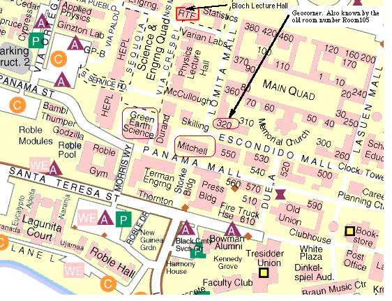
see Map showing Mitchell
Map showing Bloch
This will be the 365th meeting since 1954.
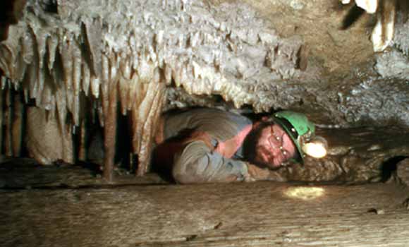
Bruce Rogers. "Well . . .. being a photographer I'm usually the one that take the pictures. I'm attaching a somewhat vintage photo of myself in a tiny crawlway in a Mother Lode cave taken in the last century. The hair color is a "bit whiter" and there's less of it, but the body is still as bruised and broken as ever . . . "
Bruce Rogers began cave exploring in the wilds of New England in the 1950's. Since then he has explored the basements of North America from the Atlantic to the Pacific and from Alaska to the Guatemala border in addition to many of the islands of the Pacific Basin. Mineralogy, general geology and geography, cartography, and history are his main spelean interests. A minor "star" of several cave films, he is also a sought after lecturer, blending science and humor in plain English. Author of several books, book chapters, and scores of articles on caves, some of his current projects include work in lava tubes, littoral caves, Pleistocene fossils in Western caves, and the cave utilization in ancient Mesoamerica.
His interest in speleology led to a formal geologic education and, after a stint as an earth science consultant in private industry, a position as a field geologist at the USGS. After billets in Oil & Gas Resources, Marine Geology and Hydrology, Alaska Geology, International Geology, and Western Regional Geology Branches, Rogers is now back on the Coastal and Marine Geology Team. He now indulges artistic, educational, and scientific bents as a scientific illustrator and education outreach specialist at the Survey's Menlo Campus. He is a life member (and Fellow) of the National Speleological Society, a Member of the Cave Research Foundation, a Director in the Western Cave Conservancy, member of the National Geographic Society, and other scientific and historical societies.
Reservations: The preferred way to make reservations is simply to email Janice Sellers at janice@seismosoc.org by Oct. 8, tell her you will attend, commit to pay, and bring your payment to the meeting. Janice always emails a confirmation; if you don't get one, assume email crashed yet again and email her a second time. A check made to "PGS" is preferred, payable at the meeting.
If you want to pay in advance:
Stanford faculty and students: Please make dinner reservations by Oct. 8. Contact Dr. Juhn Liou via his mailbox (and leave check), Geological and Environmental Sciences Office, Geocorner - Bldg. 320 (Rm. 118). Make checks out to "PGS."
All others, including faculty and students from other Bay Area universities and colleges and USGS: Please make dinner reservations by Oct. 8. Contact Janice Sellers, at Seismological Society of America, 201 Plaza Professional Building, El Cerrito, CA 94530, phone (510) 559-1780. Send check made out to "PGS" to Janice.
Dinner is $30.00. Includes wine (5:30 to 6:15 PM.), dinner (6:15-7:30 PM.), tax, and tip.
For students from all universities and colleges, the dinner, including the social 3/4-hour, is $5.00 and is partially subsidized thanks to the School of Earth Sciences, Stanford University (Note, no-show reservations owe the full price).
Doris, whose wonderful crew prepares our meals, asked that we let you know that people who are late RSVP'ing and people who show up without a reservation will be welcome but that they will be eating on paper plates with plastic utensils (food supply permitting).
Dues for Academic Year 2004-2005 ($10.00) should be sent to Janice Sellers, Seismological Society of America, 201 Plaza Professional Building, El Cerrito, CA 94530. Janice's phone: (510) 559-1780.
Officers: Cheryl Smith, President; Mike Diggles, Vice President; Vicki Langenheim, Secretary; Janice Sellers, Treasurer; Adina Paytan, Field-Trip Czarina
Date created: 09/13/2004
Last modified: 10/01/2004
Created by: Mike Diggles, Vice President, PGS.