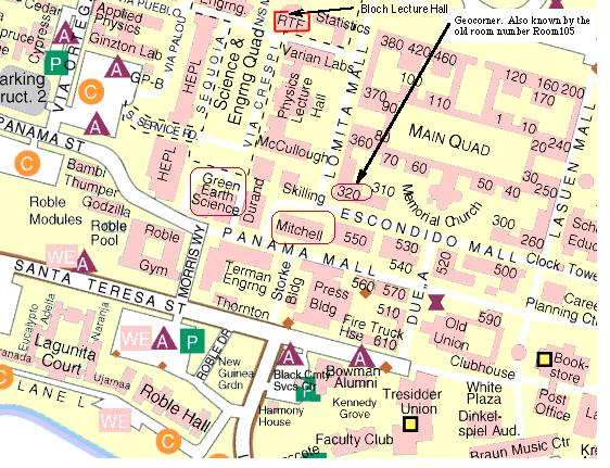
Location: Stanford University
see Map showing Mitchell and GeoCorner Room 320
This will be the 378th meeting since 1954
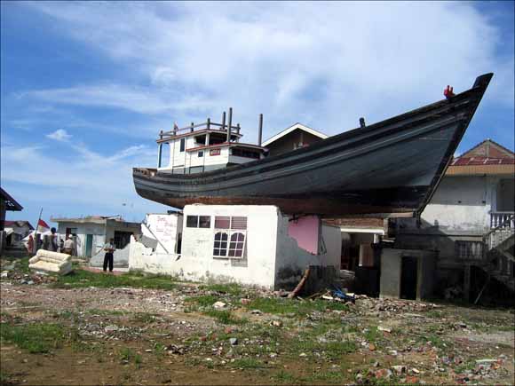
"Miracle Boat"
By George Plafker, Lloyd Cluff, Stuart Nishenko and Di Syahrial
The tsunami generated by the great Sumatra earthquake of 12/26/2004 devastated ~200 km of Sumatra coast from the Banda Aceh area on the north end of the island to Meulaboh on the west coast. Of the ~223,000 lives lost during this disaster, 72% of the casualties (~160,000) were caused by the near-field tsunami in NW Sumatra; the remaining deaths resulted from the far-field tsunami throughout the Indian Ocean.
Post-tsunami reconnaissance surveys of the northwest coast of Sumatra indicate tsunami flow depths of 5 to 12 m along the north coast and 7 to 20 m along the west coast; peak runup is ~39 m west of Banda Aceh near Lhoknga. Flow depths and run up heights are significantly larger than tectonically-generated tsunamis documented for earthquakes of comparable magnitude. The data suggest that alternate sources may have contributed to the tsunami, in addition to slip on the Sumatra megathrust (~2.8 m). Megathrust slip alone is inconsistent with arrival times and wave heights along the Sumatra coast.
Interviews were conducted on NW Sumatra with more than 110 eyewitnesses located both on land and offshore during the tsunami to investigate alternative tsunami sources. We compiled systematic data on wave arrival times, precursory sea withdrawal, number of waves, wave train characteristics, wave heights, and wave periods. Our data along the Sumatra west coast indicate that tsunami arrival time from start of the earthquake ranged from ~22 minutes near Lhoknga in the north, to ~32 minutes near Meulaboh in the south where the continental shelf is widest. Back tracing these arrival times, using a simple linear wave model, indicates a possible candidate source along the western Aceh Basin, coincident with both the steep eastern margin of the forearc high and the West Andaman fault as delineated by Sieh & Natawidjaja (2000). Our working hypothesis is that the fault is a steeply-dipping backthrust that splays off the Sumatra megathrust, and that large coseismic uplift along it in 2004 may have generated the cataclysmic near-field tsunami that struck the NW Sumatra coast.
George started out in Pennsylvania, got his B.S. (Geology) from Brooklyn College, 1949; his M.S. (Geology) from U.C. Berkeley, 1956; and his Ph.D. (Geology and Geophysics) from Stanford University, 1972. Positions he has held include Engineering Geologist, U.S. Army Corps of Engineers, 1949-1950; Geologist & Research Geologist, U.S. Geological Survey, 1951-1956, 1962-1995; Petroleum Geologist, Chevron, 1956-1961; Consulting Engineering Geologist, 1995-present. His earth-science contributions include
SELECTED PUBLICATIONS:
Plafker, G., 1965, Tectonic deformation associated with the 1964 Alaska earthquake: Science, v. 148, p. 1675-1687.
Plafker, G., 1969, Tectonics of the March 27, 1964, Alaska Earthquake: U.S. Geol. Surv. Prof. Paper 543-I, 74 p.
Plafker, G., Kachadoorian, R., Eckel, E. B., and Mayo, L. R., 1969, Effects of the earthquake of March 27, 1964, on various communities: U.S. Geol. Surv. Prof. Paper 542-G, 50 p.
Plafker, G., 1972, The Alaskan earthquake of 1964 and Chilean earthquake of 1960; Implications for arc tectonics and tsunami generation: J. Geophys. Res., v. 77, no. 5, p. 901-925.
Plafker, G., 1973, Field reconnaissance of the effects of the earthquake and tsunami of April 13, 1973, near Laguna de Arenal, Costa Rica: Bull. Seismol. Soc. Am., v. 63, no. 5, p. 1847-1856.
Plafker, G. and Brown, R. D., Jr., 1973, Surface geologic effects of the Managua earthquake of December 23, 1972, in Managua, Nicaragua earthquake of December 23, 1972: Earthquake Engineering Research Institute Conference Proceedings, Vol. I, p. 115-142
Plafker, G., 1976, Tectonic aspects of the Guatemala earthquake of 4 Feb., 1976, Science, v. 193, p. 1201-1208.
Plafker, G., and Ericksen, G. E., 1977, Nevados Huascaran avalanches, Peru: Elsevier, Amsterdam, p. 277-314.
Plafker, G. and Rubin, M., 1978, Uplift history and earthquake recurrence as deduced from marine terraces on Middleton Island, Alaska in Methodology for identifying seismic gaps and soon-to-break gaps: U.S. Geol. Surv. Open-File Rept. 78-943, p. 687-721
Plafker, G., Hudson, T., Bruns, T., and Rubin, M., 1978, Late Quaternary offsets along the Fairweather fault and crustal plate interactions in southern Alaska: Can. Jour. of Earth Sci., v. 15, no. 5, p. 805-816.
Plafker, G., and Eyzaguirre, V. R., 1979, Rock avalanche and wave at Chungar, Peru, in Voight, B., ed., Rockslides and avalanches, v. 2, Engineering sites: Elsevier, Amsterdam, p. 269-279.
Plafker, G. and Ward, S. N., 1992, Backarc thrust faulting and tectonic uplift along the Caribbean Sea coast during the April 22, 1991 Costa Rica earthquake: Tectonics, v. 11, no. 4, p. 709-718.
Plafker, G. and Berg, H. C., 1994, An overview of the geology and tectonic evolution of Alaska, in Plafker, G. and Berg, H.C., eds., The geology of Alaska: Boulder, Colorado, Geol. Soc. of Am., The Geology of North America, v. G1, p. 989-1021.
Plafker, G., Gilpin, L. M., and Lahr, J. C., 1994, Neotectonic map of Alaska, in Plafker, G., and Berg, H.C., eds., The geology of Alaska: Boulder, Colorado, Geol. Soc. of Am., The Geology of North America, v. G1, Plate 12, 1 sheet with text, scale 1:2,500,000.
Plafker, G., Moore, J. C., and Winkler, G. R., 1994, Geology of the southern Alaska margin, in Plafker, G. and Berg, H.C., eds., The geology of Alaska: Boulder, Colorado, Geol. Soc. of Am., The Geology of North America, v. G1, p. 389-449.
George Plafker
Reservations: The preferred way to make reservations is simply to email Janice Sellers at janicemsj@gmail.com by March 10, tell her you will attend, commit to pay, and bring your payment to the meeting. Janice always emails a confirmation; if you don't get one, assume email crashed yet again and email her a second time. A check made to "PGS" is preferred, payable at the meeting.
If you want to pay in advance:
Stanford faculty and students: Please make dinner reservations by March 10. Contact Dr. Elizabeth Miller via her mailbox (and leave check), Geological and Environmental Sciences Office, Geocorner - Bldg. 320 (Rm. 205). Make checks out to "PGS."
All others, including faculty and students from other Bay Area universities and colleges and USGS: Please make dinner reservations by March 10. Contact Janice Sellers, at 1066 28th Street, Oakland, CA 94608-4547, (510) 268-8254 . Send check made out to "PGS" to Janice.
Dinner is $30.00. Includes wine (5:30 to 6:15 PM.) and dinner (6:15-7:30 PM.).
For students from all universities and colleges, the dinner, including the social 3/4-hour, is $5.00 and is partially subsidized thanks to the School of Earth Sciences, Stanford University (Note, no-show reservations owe the full price).
Doris, whose wonderful crew prepares our meals, asked that we let you know that people who are late RSVP'ing and people who show up without a reservation will be welcome but that they will be eating on paper plates with plastic utensils (food supply permitting).
Dues for Academic Year 2005-2006 ($10.00) should be sent to Janice Sellers, 1066 28th Street, Oakland, CA 94608-4547. Janice's phone: (510) 268-8254.
Officers: Ray Wells, President; Dwight Harbaugh and Elizabeth Miller, Co-Vice Presidents; Mike Diggles, Secretary; Janice Sellers, Treasurer; Bob Coleman, Field-Trip Czar
Date created: February 21, 2006
Last modified: March 7, 2006
Created by: Mike Diggles, Webmaster-Secretary, PGS.