Location: Stanford University
This will be the 408th meeting since 1954
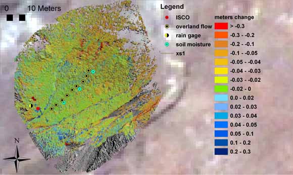
In tropical watersheds, hillslope changes are producing increasing amounts of fine sediment that can be quickly carried to reefs by channels. Suspended sediment concentrations off the reefs of Moloka‘i, Hawai‘i, chronically exceed a toxic level of 10 mg/L, threatening reef ecosystems. We hypothesize that historic overgrazing converted watershed erosion from soil creep to overland flow, increasing both the magnitude and frequency of sediment flooding adjacent reefs. We combined surficial and ecological mapping, hillslope and stream gages, and novel sensors to locate, quantify and model the generation of fine sediments polluting the Moloka‘i reef. We find that small areas of intense soil erosion (~1 cm/year) are active between 8–10 hours every year with large storms whose rainfall intensities exceed 10 mm/hour. These hot-spots erode at rates that are at least 100-fold greater than long-term rates of 0.13 mm/year. High modern rates appear to depend on the availability of loose particles, which are refreshed annually by intense weathering of unvegetated soil. When summed up over the catchment, predicted hot-spot erosion nearly balances that observed at the catchment mouth. A small portion (< 3%) of the landscape appears to be responsible for the majority of the sediment pollution to the reef. Expansion of these hotspots as climate change alters vegetation cover or storm characteristics could increase sediment pollution of the reef dramatically.
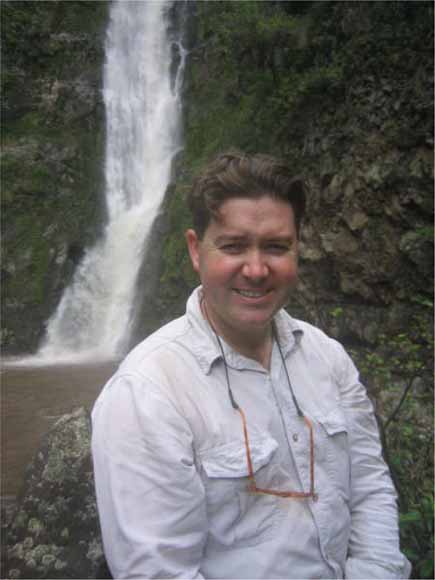
Jonathan Stock
Jonathan Stock is a Research Geologist in the Western Region Geology & Geophysics Science Center, USGS, Menlo Park. He investigates the role of geomorphic processes in shaping Earth’s surface by combining new mapping technologies with field-based monitoring and measurements, and theoretical modeling. He uses the mapping to delineate the extent of different geomorphic processes, the field measurements and monitoring to quantify their rates, and the modeling to generalize these local results for both environmental and hazard applications. The goal of his research is to understand the processes that produce and transport sediment in steeplands at a level at which their transport rates can be forecast. His current projects include high-resolution landslide mapping using LiDAR in the Ventura area, a process model for sediment supply to the reef in Moloka‘i, near-real-time landslide monitoring sensors in the San Francisco Bay Area, use of bathymetric LiDAR to assess sediment supply on the Klamath River, and use of new environmental sensors and repeat LiDAR to assess post-wildfire hazards in southern California. He communicates this science at invited academic talks here and abroad, but also at grade-school and community meetings in his fieldsites. He was educated at U.C. Santa Cruz (B.Sc., 1992), University of Washington (M.Sc., 1996) and University of California, Berkeley (Ph.D., 2003).
Reservations: The preferred way to make reservations is simply to email John Spritzer at jspritzer@usgs.gov by Oct. 2, tell him you will attend, commit to pay, and bring your payment to the meeting. John always emails a confirmation; if you don’t get one, assume email crashed yet again and email him a second time. A check made to “PGS” is preferred, payable at the meeting.
If you want to pay in advance:
Everyone (including Stanford folks now) Please make dinner reservations by Oct. 2. Contact John Spritzer, at U.S. Geological Survey, 345 Middlefield Road, MS-973 Menlo Park, CA 94025, Tel.: (650) 329-4833. Send check made out to “PGS” to John.
Dinner is $35.00. Includes wine (5:30 to 6:15 PM.) and dinner (6:15-7:30 PM.).
For students from all universities and colleges, the dinner, including the social 3/4-hour, is $8.00 and is partially subsidized thanks to the School of Earth Sciences, Stanford University (Note, no-show reservations owe the full price).
Doris, whose wonderful crew prepares our meals, asked that we let you know that people who are late RSVPing and people who show up without a reservation will be welcome but that they will be eating on paper plates with plastic utensils (food supply permitting).
Dues for Academic Year 2009-2010 ($10.00) should be sent to John Spritzer, U.S. Geological Survey, 345 Middlefield Road, MS-973 _Menlo Park, CA 94025. John’s phone: (650) 329-4833.
Officers: Vicki Langenheim, President; Jon Hagstrum, Vice President; Mike Diggles, Secretary; John Spritzer, Treasurer; Elizabeth Miller, PGS Stanford University Coordinator
Date created: September 9, 2009
Last modified: September 9, 2009
Created by: Mike Diggles, Webmaster-Secretary, PGS.