Presents
Location: Stanford University
This will be the 438th meeting since 1954
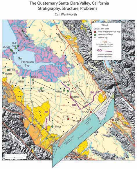
The gradually subsiding Santa Clara basin has accumulated as much as about 1,500 feet of Quaternary alluvium over the past 1? Ma. This section consists of a lower finer grained interval and, above a mid-Quaternary unconformity, an upper interval that consists of eight upward fining cycles. The unconformable bases of these cycles correlate with the past eight principal climatic minima, as represented by the marine oxygen isotope curve, and the resulting subsidence curve indicates steady subsidence, relative to high-stand sea level, of 0.38 mm /yr. Dating of the sections comes both from that correlation and paleomagnetic identification of the Big Lost polarity excursion (565 ka) and the Brunhes/Matuyama boundary (780 ka), which track slightly beneath cycles 6 and 8, respectively. No gravels similar to the Plio-Quaternary Santa Clara, Packwood, Silver Creek, or Irvington gravels occur at the base of the section, contrary to expectations.
The largely undeformed basal unconformity truncates a central basement high, the westward thickening Miocene Cupertino basin on the west, and the late Cenozoic Evergreen pull-apart basin on the east. Zones of reverse and thrust faults define the west and east boundaries of the basin. The eastern, Evergreen system extends as thrusts into and across the top of the Evergreen basin, the timing of which can be partially inferred from thinning of overlying strata. Contrary to previous representations, the interior of the Santa Clara basin seems unfaulted other than by the Silver Creek fault, which forms the western boundary of the Evergreen basin. Steep faults at the margins of that basin have absorbed nearly all the 175 km of right slip assigned to the East Bay portion of the San Andreas fault system: at least 40 km on the Silver Creek fault and more than 100 km on the concealed Mt Misery fault, which obliquely truncated the Evergreen basin early in its history.
Problems: (1) The top of cycle 2 is marked by a coarse grained interval that interrupts the climate-controlled sequence of cycles and is most poorly defined along the drainage axis where a pulse of coarse sediment ought to be most evident. (2) Although containing several erosional unconformities, the Santa Clara basin is bounded on both the southeast and northwest by bedrock highs against which the alluvial fill abuts, leaving no clear drainage outlet below cycle 6 (depth about 600 ft at Dumbarton narrows). (3) The long, narrow basement block (~20 km wide, perhaps 100 or more km long) was below sea level to accumulate Miocene sediment, above sea level for erosion to truncate the Cupertino basin and remove any Plio-Quaternary gravels, and is now again subsiding, a behavior for which no simple mechanism is evident.
Carl Wentworth
Carl Wentworth is an Emeritus Geologist with the U.S. Geological Survey in Menlo Park, having retired in 2004. After studying geology at Dartmouth and Stanford, he joined the Survey full time in 1963, and was soon assigned to work on the geologic setting of a proposed nuclear power reactor in Malibu, California. That experience redirected his career toward tectonics, Quaternary geology, and geologic hazards. He has engaged in geologic mapping, engineering characterization of geologic materials, landslide studies, conceiving and managing a research program on geologic hazards to nuclear power reactors, deep seismic reflection exploration across the eastern front of the California Coast Ranges, study of the origin of the 1982 Coalinga earthquake, application of GIS to compilation and analysis of geologic maps, 3-D geologic map compilation, and multidisciplinary study of the Santa Clara Valley.
Reservations: The preferred way to make reservations is simply to email Mike Diggles at mdiggles@usgs.gov by March 10, tell him you will attend, commit to pay, and bring your payment to the meeting. Mike always emails a confirmation; if you don’t get one, assume email crashed yet again and email him a second time. A check made to “PGS” is preferred, payable at the meeting.
If you want to pay in advance:
Everyone (including Stanford folks now) Please make dinner reservations by March 10. Contact Mike Diggles, at U.S. Geological Survey, 345 Middlefield Road, MS-951 Menlo Park, CA 94025, Tel.: (650) 329-5404. Send check made out to “PGS” to Mike.
Dinner and the social hour is $35.00; this includes $5 that we use to help pay for students who are only $8.00 (also partially subsidized thanks to the School of Earth Sciences, Stanford University (Note, no-show reservations owe the full price).
Doris, whose wonderful crew prepares our meals, asked that we let you know that people who are late RSVPing and people who show up without a reservation will be welcome but that they will be eating on paper plates with plastic utensils (food supply permitting).
Dues for Academic Year 2012-2013 ($10.00) should be sent to Mike Diggles, U.S. Geological Survey, 345 Middlefield Road, MS-951, Menlo Park, CA 94025. Mike’s phone: (650) 329-5404.
Officers: Joe Colgan, President; Mike Diggles, Secretary-Treasurer; Elizabeth Miller, PGS Stanford University Coordinator
Date created: March 3, 2013
Last modified: April 2, 2013
Created by: Mike Diggles, Webmaster-Secretary-Treasurer, PGS.